News
‹ back to weather news
News
-
What caused the deadly floods in Spain this week?
James Rout, 2 November 2024Devastating floods swept through parts of southeastern Spain including Valencia this week, tragically leaving a trail of death and destruction in their wake. What meteorological factors combined to create such a catastrophic event?
Spanish floods kill 95 as year of rain falls in a day in Valencia | Reuters
The catalyst for the flooding was a cut-off low that descended from the north down to the Iberian Peninsula. This upper-level low was near-stationary over the region for several days and intensified a surface low pressure system which was slow-moving and caused intense thunderstorms.
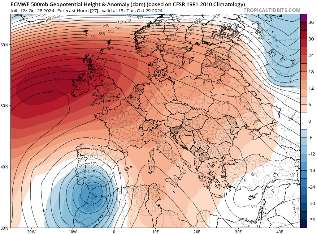
Image: 500hPa height anomaly at 15Z Tuesday Oct 29th, showing the cut-off low in blue (ECMWF model). Source: tropicaltidbits.com
The Mediterranean Sea, still warm from summer, played a role in fueling the system. Sea surface temperatures around 20-22°C provided an ample source of moisture and energy for the developing system. The sea surface temperatures have cooled from their annual peak but are still running above average as they have throughout this year.
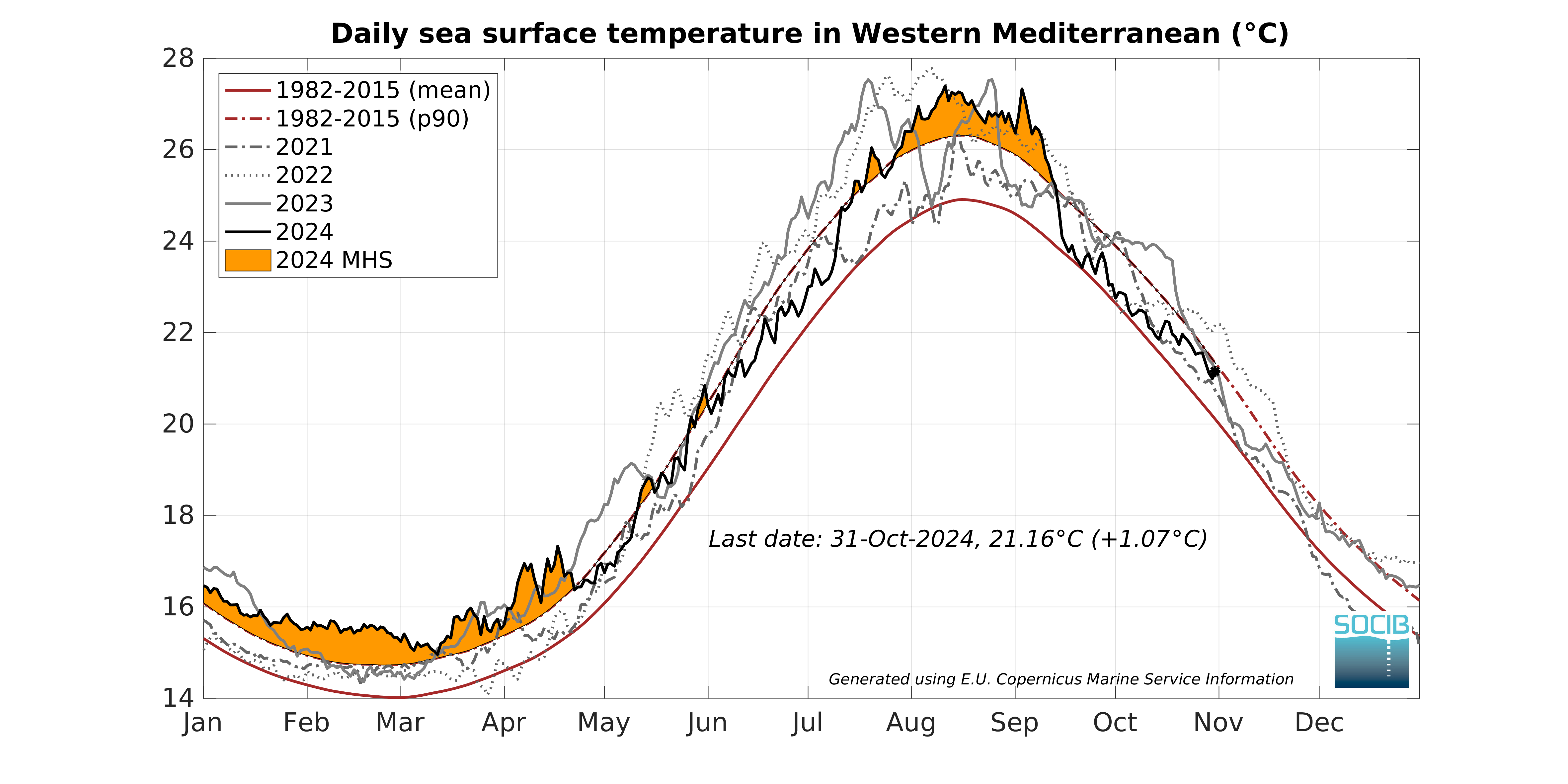
Image: Daily sea surface temperature for the Western Mediterranean Sea. Source: Balearic Islands Coastal Observing and Forecasting System (SOCIB)
The counter-clockwise rotation around the deepening surface low caused easterly winds to funnel warm, moisture-laden air from the Mediterranean Sea towards Spain.
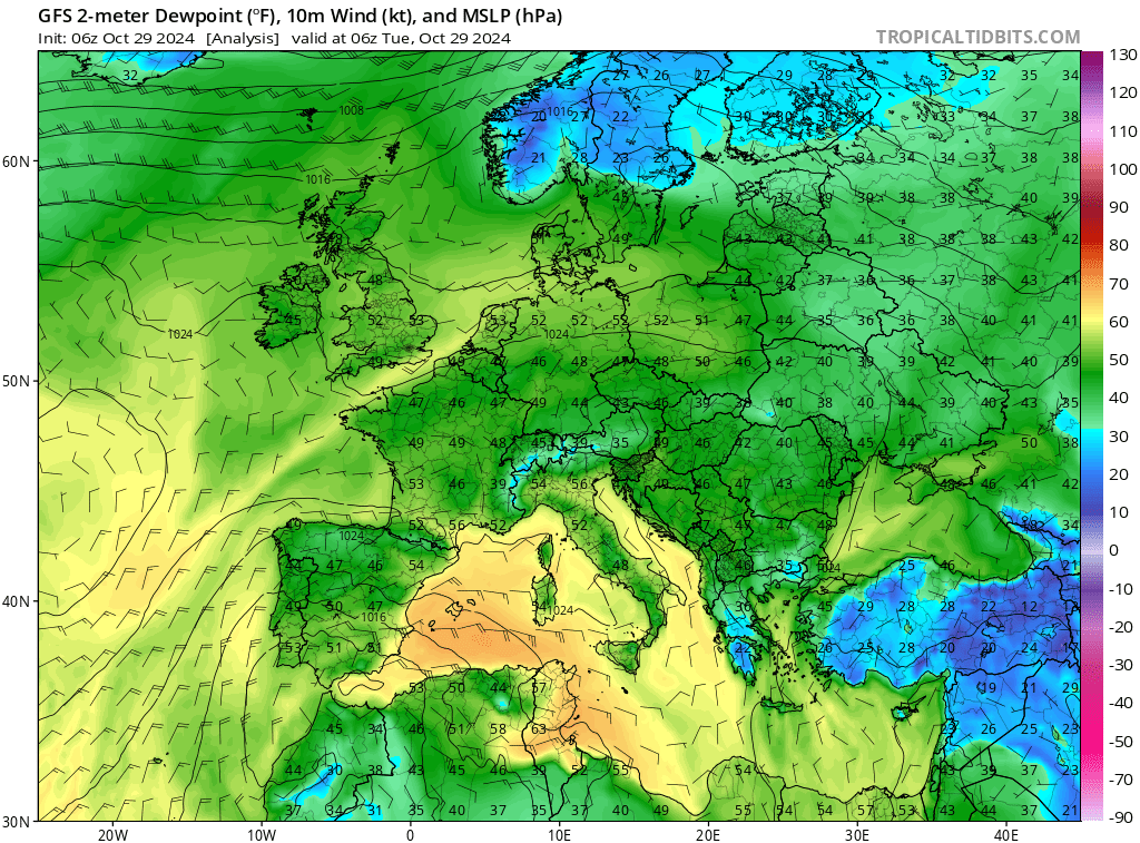
Image: Dewpoint temperature (degrees F) at 6Z Tuesday Oct 29th, showing easterly winds pulling humid air into eastern Spain from the Mediterranean Sea (GFS model). Source: tropicaltidbits.com
With warm, humid air at the surface and cooler air aloft, the atmosphere became convectively unstable. This unstable air, combined with the lifting mechanism provided by the low pressure system, triggered intense thunderstorm activity. The mountainous terrain inland from the coast enhanced the rainfall as easterly winds were forced up the steep slopes.
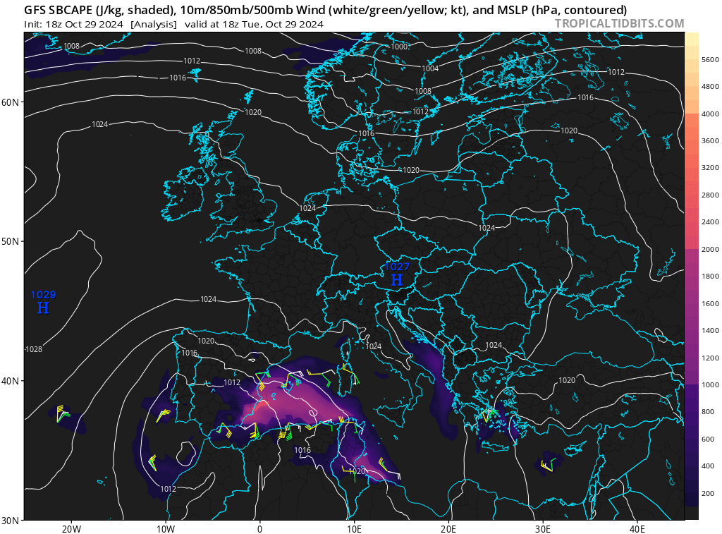
Image: Purple and orange shading shows the energy available to thunderstorms at 18Z Tuesday 29th, October (GFS model). Source: tropicaltidbits.com
The slow-moving nature of the low caused thunderstorms to train over the same areas, leading to intense rainfall that overwhelmed drainage systems and caused flash flooding. An area west of Valencia even recorded more than a year's worth of rain in less than a day.
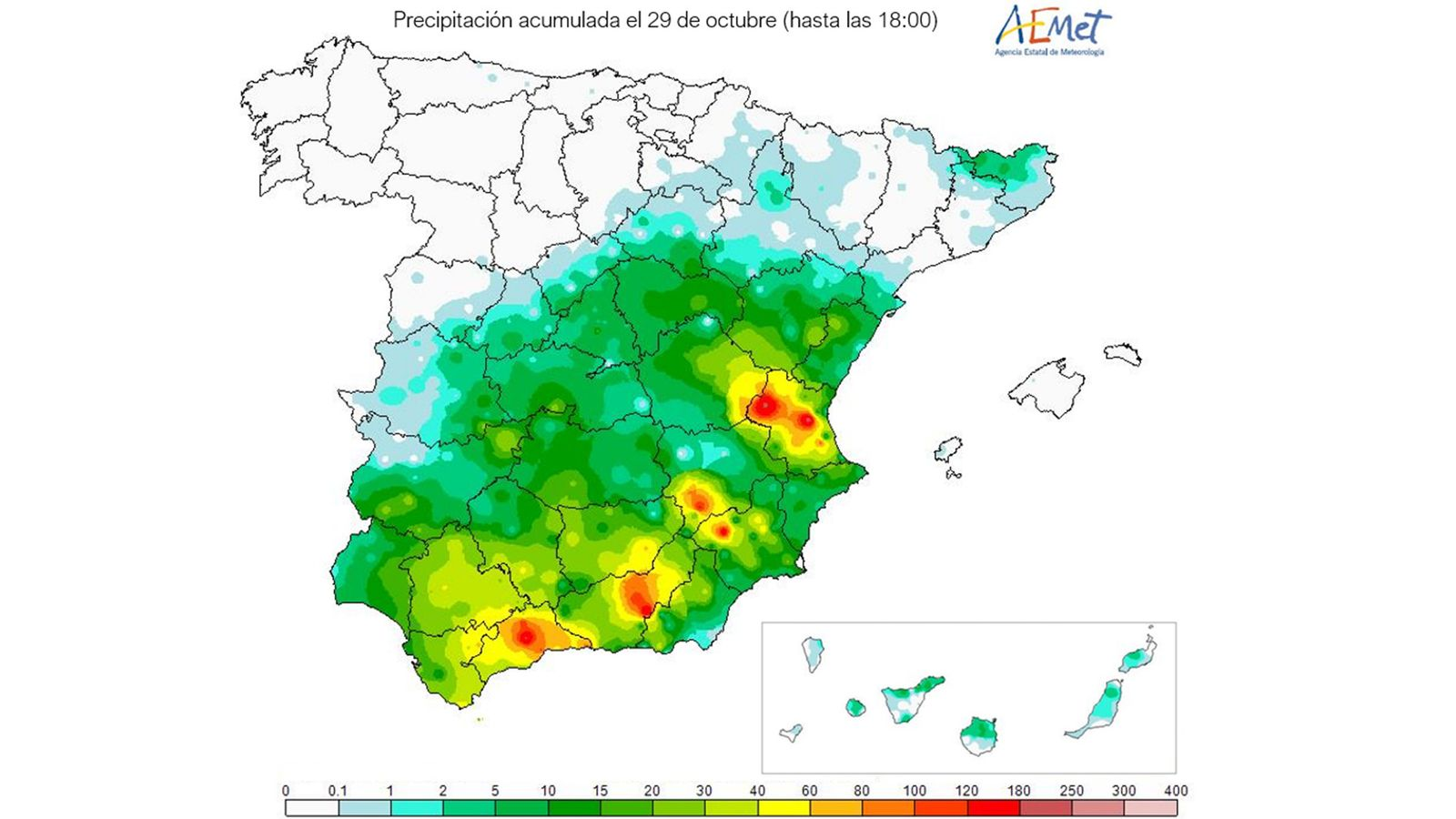
Image: Rainfall totals (mm) on Tuesday the 29th of October to 6pm local time. Source: Agencia Estatal de Meteorología - AEMET
One of the highest daily totals for the Valencia area was 230.4mm at Utiel.
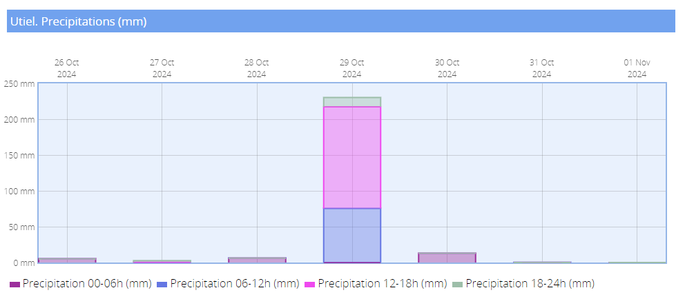
Image: 24 hour rainfall totals for Utiel in the Valencia district (26th Oct to 1st Nov). Source: AEMET.
The floods were large enough that they were visible from space. The following imagery shows the before and after scenes around Valencia. The muddy flood waters are visible as large areas of orange on the right image.
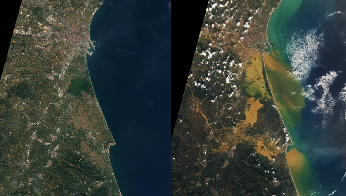
Image: Landsat 8 satellite imagery. Left: Friday October 25th. Right: Wednesday October 30th. Source: NASA
Unfortunately, these atmospheric ingredients, coming together all at once, created an intense weather system that has left terrible devastation.
- Other news
- Sat 14 Dec 2024 Australia's heatwaves: the scorching past and present
- Fri 13 Dec 2024 Huge heatwave about to bake Australia
- Fri 13 Dec 2024 Canberra facing hottest day in almost five years
- Thu 12 Dec 2024 Victoria's first 45°C in four years on the horizon
- Thu 12 Dec 2024 'Everest of the Seas' races through Aussie waters

