News
‹ back to weather news
News
-
Amazon Forest is burning
Aline Ribeiro, 14 September 2024Since the beginning of the year, around 9 million hectares — an area larger than the state of Tasmania —have been burned in Brazil, almost matching the total number of fires from all of last year. Smoke from the fires has spread across South America, mainly in August and in the first half of September. The satellite images below are shocking, and the consequences are disastrous across the continent, particularly for the residents of Brazil, Bolivia, and Ecuador.
.gif)
Normally, moisture from the Amazon is transported to central-southern Brazil through the South Atlantic Convergence Zone (SACZ), which is responsible for the largest volumes of rainfall in the southeast, contributing to water supply and energy generation. This year, we have seen aerosols spread and suffocate the central south of the continent, causing serious respiratory problems, evacuations, school closures, flight cancellations, and threats to animal and plant life.
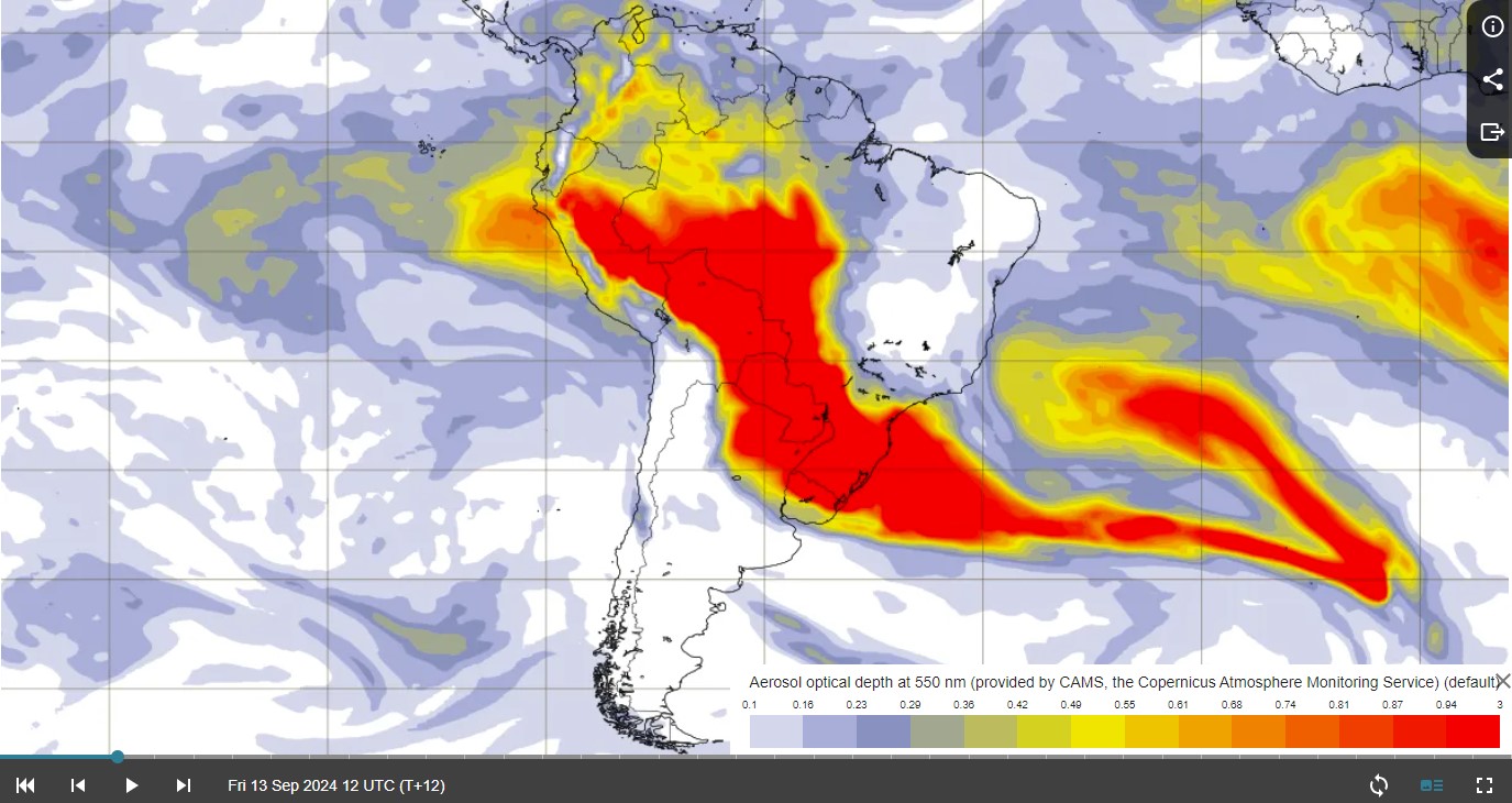
Image: Aerosol optical depth (nm) for South America. Source Copernicus.
What makes this scenario worse is an exceptional drought that has been affecting parts of Brazil for the last three months. Winter is usually dry in Brazil, but in 2024 was atypical. The map below shows how much the observed precipitation deviates from the climatological average or the Standardized Precipitation Index (SPI). The red colour represents the maximum value, indicating that the imbalance between water supply and demand is resulting in an extreme drought (D4) in much of South America.
.png)
Image: 3-Month ERA5 Global SPI across South America.
The combination of historic droughts and wildfires can have devastating effects not only in South America but may also contribute further to climate change around the world.
- Other news
- Thu 19 Sep 2024 Massive temperature contrasts in SE Australia
- Wed 18 Sep 2024 Don't miss tonight's supermoon over Australia
- Wed 18 Sep 2024 How Storm Boris became 'the perfect storm'
- Tue 17 Sep 2024 Darwin hasn't seen September rain like this for decades
- Tue 17 Sep 2024 Extreme fire danger predicted in Sydney this Thursday