News
‹ back to weather news
News
-
Severe thunderstorms loom for NSW, Vic, Qld, ACT
Ashleigh Madden, 15 November 2024Another dangerous thunderstorm outbreak is on the cards for eastern and southeastern Australia from this weekend into next week, with parts of NSW and Vic also forecast to see large daily rainfall totals.
It has been a stormy week for eastern Australia with areas of northeast NSW and southeast Qld accumulating more than 200mm of rain, with more storms expected on Friday.
The next round of thunderstorms will impact parts of Vic and NSW on Sunday and Monday as a cold front moves over the country’s southeastern states.
The atmosphere will be very unstable in southeastern and eastern Australia from this weekend, with warm and humid air to be lifted by the cold front and trough above the surface helping to create large thunderstorms.
The image below shows the forecast lifted Index (a measure of atmospheric instability) for Sunday afternoon, with the blue shades showing an unstable atmosphere across parts of NSW, Qld and Vic.

Image: Lifted Index values at 2pm on Sunday, November 17 afternoon. Areas with lower values (the white and blue shading) show where the atmosphere is potentially unstable, greatly increasing the risk of thunderstorms developing.
This unstable atmosphere is likely to generate some severe thunderstorms, with heavy rainfall and damaging winds the main risks on Sunday and Monday.
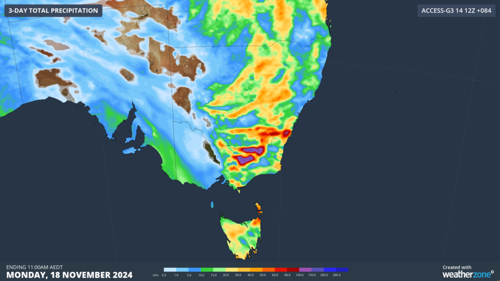
The cold front and associated thunderstorm activity is also expected to bring significant rainfall to the northern ranges in Vic and southeastern NSW.
The image below shows that more than 100mm of rain could fall in these areas over the coming days.

Image: Accumulated precipitation for the 3 days leading up to Monday, November 18, according to access-G
On Sunday, daily totals could reach 60 to 80mm in thunderstorm activity, with a risk of flash flooding.
While rain will ease on Monday, thunderstorm activity will continue across parts of NSW and Qld early next week.
- Other news
- Fri 15 Nov 2024 Temperature and fire danger soaring this weekend
- Thu 14 Nov 2024 Indonesian ash plume still visible from space as flights resume
- Thu 14 Nov 2024 A positive SAM has arrived – here's what it means for Australian weather
- Wed 13 Nov 2024 Evening storms slam Brisbane, miss Canberra and Sydney
- Wed 13 Nov 2024 Severe storms striking eastern Australia on Wednesday

