News
‹ back to weather news
News
-
Rain and storms flood part of five Australian states
Brett Dutschke, 1 December 2024Rain and thunderstorms across Australia's east and south in the past few days peaked on the weekend, delivering the biggest downpours in years in five states, leaving some areas flooded, even in the capitals.
Parts of Queensland, New South Wales, the Australian Capital Territory, Victoria, Tasmania and South Australia all received their biggest falls in years.
The most significant flooding has been occurring in Queensland, in the far southeast, where the Gold Coast hinterland was saturated with falls exceeding 200mm in under 24 hours, leading to major flooding. Some river levels rose by about 10 metres in under 12 hours, catching many nearby residents and travellers by surprise. Roads were cut off, forcing drivers to abandon their vehicles and call for help.
Capital cities Brisbane, Sydney, Canberra and Hobart were all drenched by heavy downpours all within 24 hours of each other, a few simultaneously, making flight travel between them problematic.
In just one hour, Brisbane copped more than 40mm, Sydney more than 25mm and Canberra and Hobart about 10mm each. Some suburbs in each other these cities received significantly more in as much time, amounting to more than 50mm in a little over an hour, easily enough to bring flash flooding.

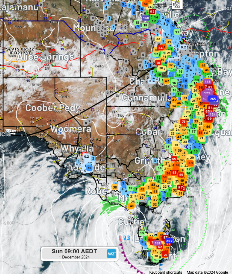
Image: Rainfall in millimetres from 9am Saturday to 9am AEDT Sunday with a background of satellite, radar and the synoptic pattern.
Some of the biggest daily rainfall totals in each state and territory include -
- 265mm in Upper Springbrook (Queensland)
- 207mm in Gray (Tasmania)
- 186mm in Tumbulgum (NSW)
- 100mm in Brindabellas (ACT)
- 59mm at Portland (Victoria)
- 44mm at Parrakie (SA)
It was the heaviest rain in seven years in SA's Parrakie (44mm), more than four years in Tasmania's Eaglehawk Neck (103mm), three years at both Queensland's Urbenville (109mm) and NSW's Urbenville (79mm), more than two years at Victoria's Apollo Bay (40mm), and one year in the ACT's Canberra (40mm).
This sort of rainfall is more typical of late summer, rather than earlier summer or late spring. This is largely due to the amount of moisture that has been building up in the atmosphere during the past week. Moisture has been filtering in from the northwest and the east into a low pressure trough which has been so slow-moving that moisture has reached levels normally only experienced in January or February.
This is the highest daily December rainfall in more than 90 years in Queensland's Eaglehawk Neck, more than 60 years in Queensland's Highvale (128mm), more than 25 years in Victoria's Cape Nelson (57mm), 13 years in SA's Parrakie and 10 years in the ACT's Canberra.
Looking ahead, this trough is now taking the biggest rainfall off the east coast. However, another trough, causing severe storms in Western Australia on Sunday, will move east to scatter intense rain and storms across each state and territory during the coming week. Those in central and eastern Australia will need to be on guard, listen out for warnings and put up with another spell of warm, humid and wet weather.
- Other news
- Mon 02 Dec 2024 Australia faces high fire danger this summer
- Mon 02 Dec 2024 What to expect for Australia's first week of summer
- Mon 02 Dec 2024 Australia registers warmest spring on record
- Sat 30 Nov 2024 Brisbane's warmest spring on record
- Sat 30 Nov 2024 Heavy rain, low cloud frustrate travellers in eastern Australia

