News
‹ back to weather news
News
-
Back-to-back winter storms for the UK
Joel Pippard, 23 January 2025Storm Éowyn is approaching the United Kingdom, packing forecast wind gusts upwards of 130 km/h on Friday, while another powerful storm looks to arrive within three days of the first.
Storm Éowyn is an intense low-pressure system that is spinning up over the North Atlantic from the same bitterly cold airmass that saw nearly all of the United States see below average temperatures this week. Storm Éowyn is the fifth storm of the season to be named.
In the UK, intense winter low pressure systems (storms) are given names by the UK Met Office, akin to how other countries give names to tropical cyclones. By naming the systems, it is easier to communicate how different these storms can be from one other. While nearly all storms bring gale-to-storm force winds, some also bring heavy snow, freezing rain, or flooding.
The storm is expected to arrive over Ireland and the UK from the late evening on Thursday, with its most powerful winds expected in the middle of the day on Friday. Wind gusts are broadly expected to peak at 95-115 km/h for most inland areas, and upwards of 130-145 km/h for the exposed coast, hills and highlands. As the storm crosses the region, winds will shift from an initial southeasterly direction to a more westerly direction as it clears on Saturday.
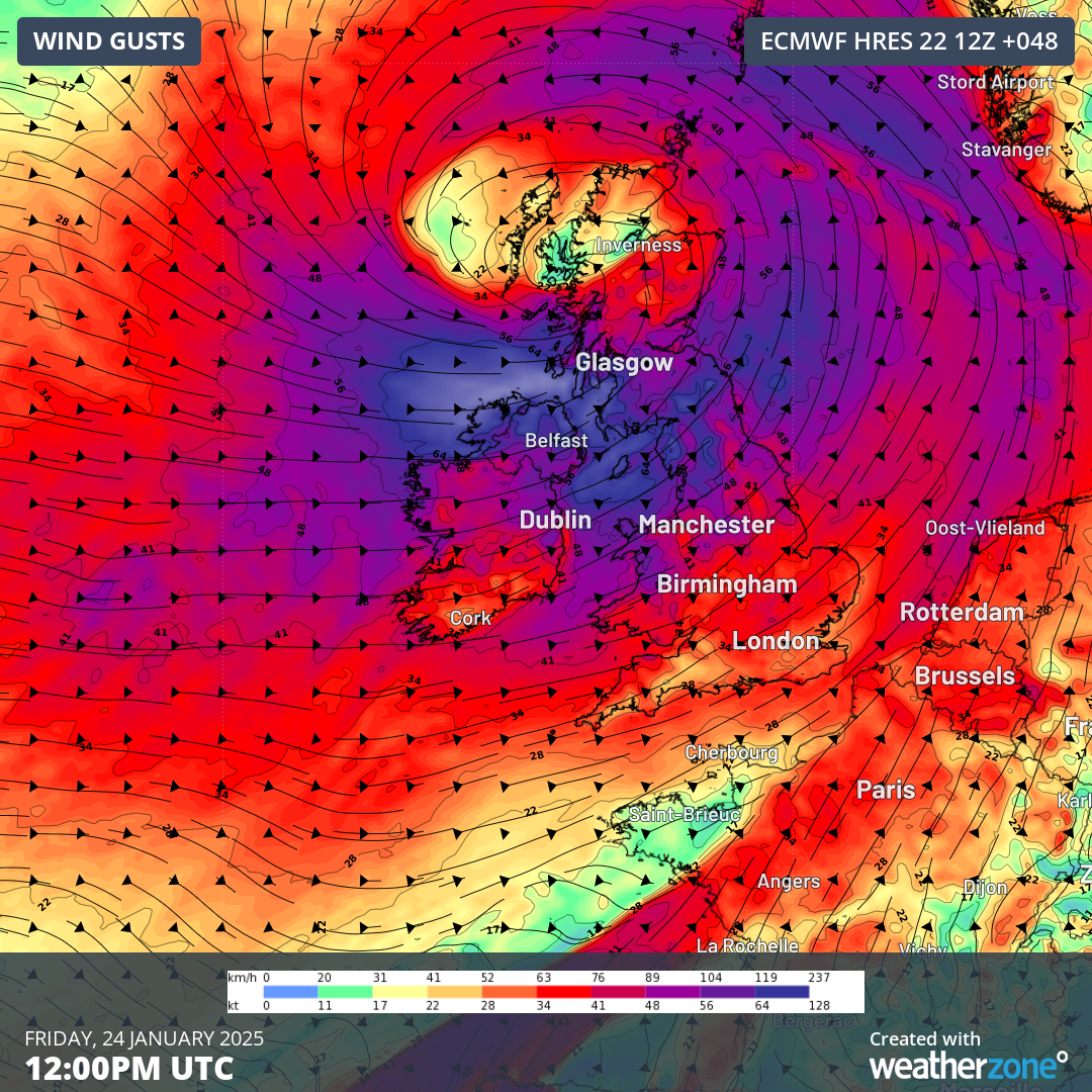
Image: Forecast wind gusts from ECMWF for Storm Éowyn on Friday. Source: Weatherzone
One less common aspect of Storm Éowyn is that it will feature a warm-core, rather than a cold-core. Warm-core lows have some origins in the tropics or sub-tropics, and, since warmer air can hold much more water than cold air, are often wetter with milder temperatures than the typical cold-core storm.
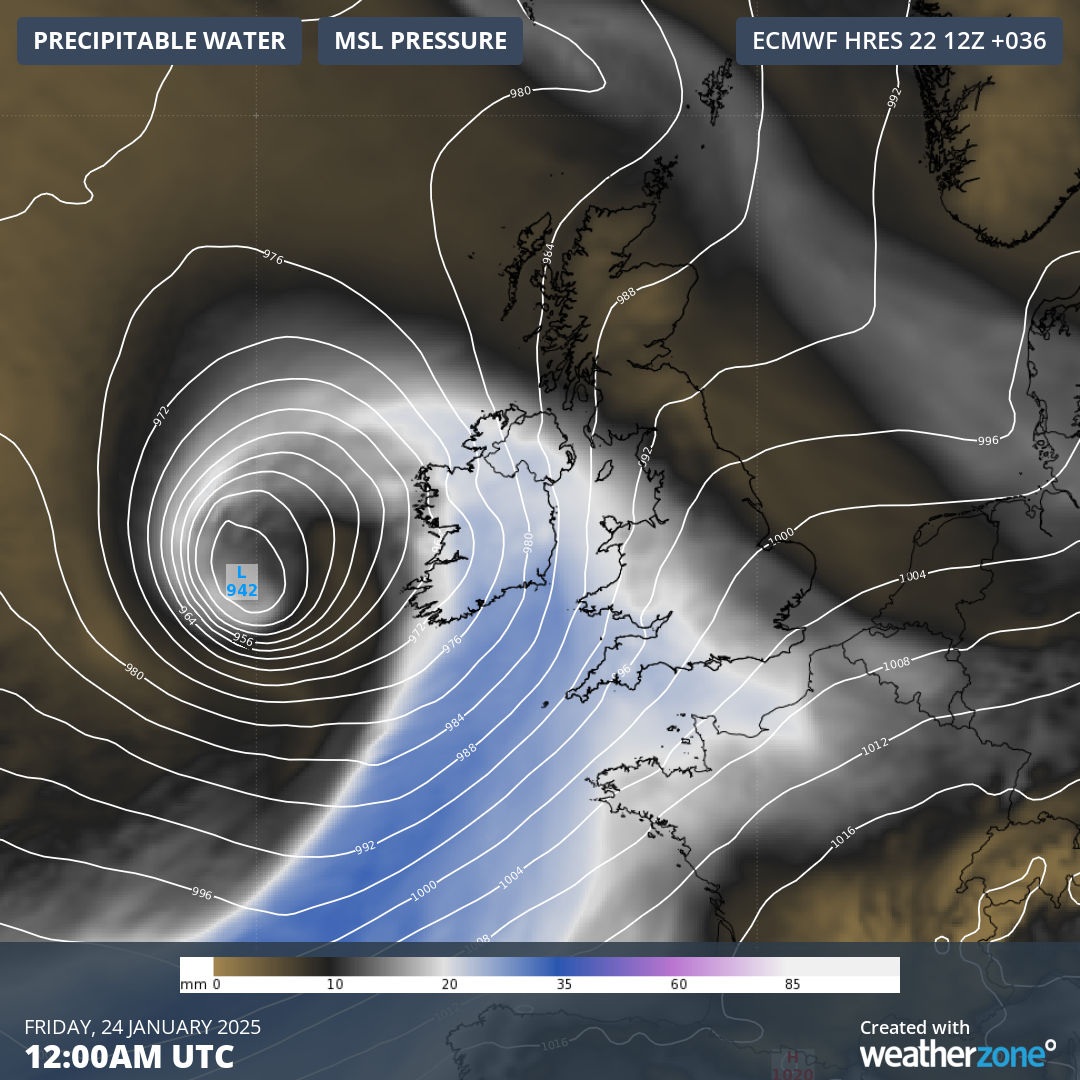
Image: Forecast precipitable moisture from ECMWF on Friday. The blue streak shows moisture being dragged over the UK from the sub-tropics to the south. Source: Weatherzone
Widespread falls of 20-40mm are expected on Friday, with isolated pockets of Wales and southern England expected to receive up to 80mm. Most of this precipitation will fall as snow over Northern Ireland and the Scottish Highlands, with a light dusting for the remaining eastern half of the UK.
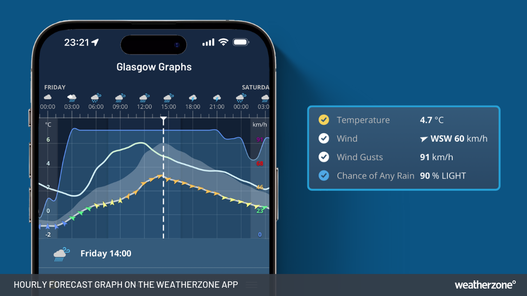
Image: Forecast temperature, sustained winds, wind gusts and precipitation chance for Glasgow on Friday from the Weatherzone App.
Only a few days after Storm Éowyn passes, another intense storm looks to cross the UK on Monday. While it's still uncertain what specific impacts it will have, initial forecasts suggest it will pack slightly weaker winds strengths as Éowyn, but over a broader area, and potentially last for longer.
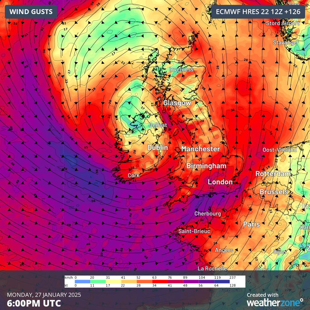
Image: Forecast wind gusts from ECMWF on Monday for the next storm. Source: Weatherzone
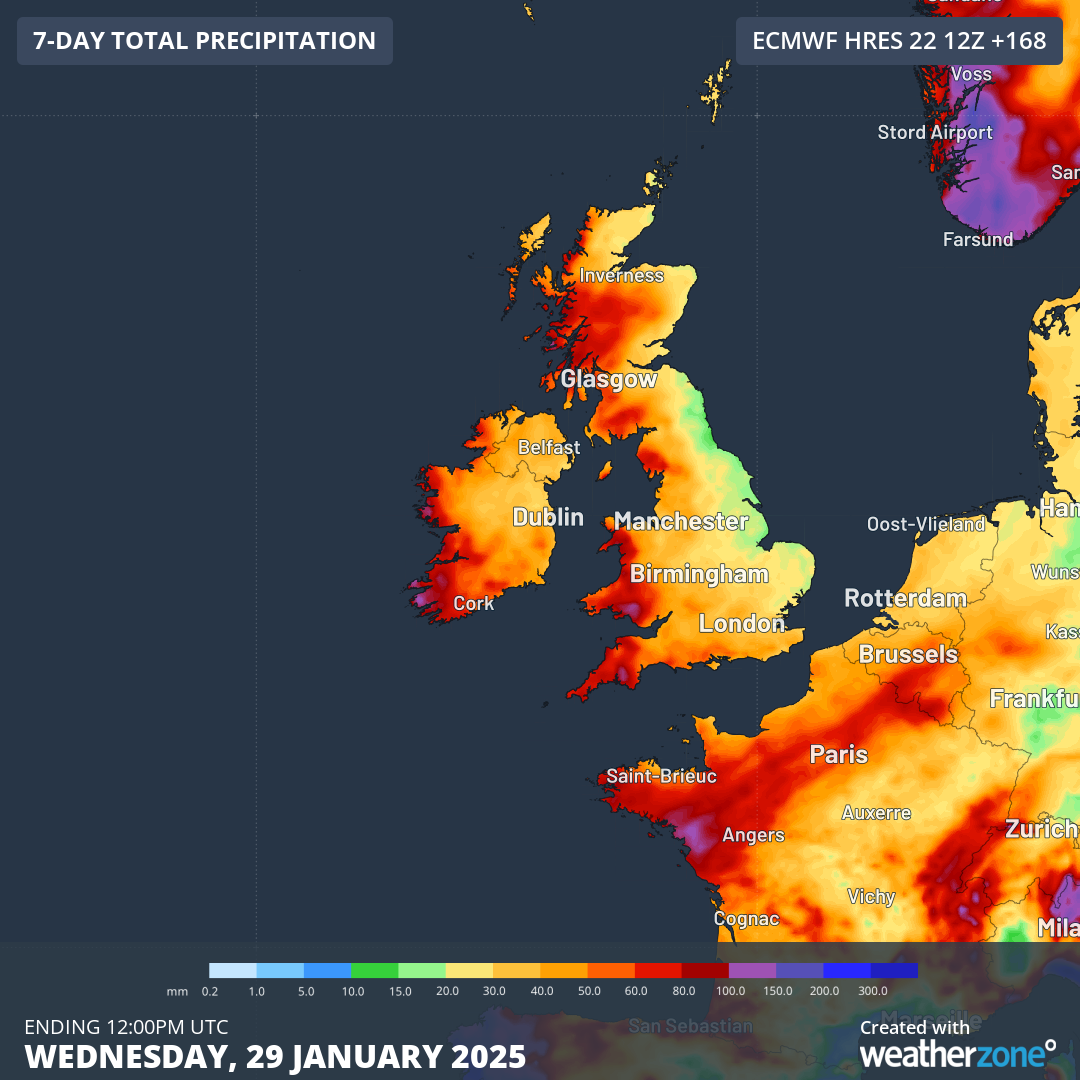
Image: Forecast weekly precipitation from ECMWF, mainly falling during the two storms. Source: Weatherzone
To see the latest warnings for Storm Éowyn and the likely storm forming in its wake, you can visit the UK Met Office.
- Other news
- Thu 23 Jan 2025 Snow in New Orleans? That's like a blizzard in Coffs Harbour
- Thu 23 Jan 2025 Fierce morning storm lashes Byron Bay, Gold Coast
- Wed 22 Jan 2025 Vast arc of heat to sear Australia’s interior for a week
- Wed 22 Jan 2025 Sydney's hottest day of 2025, then strong southerly
- Tue 21 Jan 2025 Perfect Melbourne weather for Australian Open finals

