News
‹ back to weather news
News
-
Big stormy end to spring looms for Australia
Ben Domensino, 25 November 2024Rain and thunderstorms will hit part of every state and territory in Australia this week, with flash flooding a heightened risk amid the late-spring severe storm outbreak.
Several factors will align to cause prolific rain and thunderstorm activity over Australia this week:
- A hot air mass will linger over northern and eastern Australia, providing some of the energy required for storm development.
- A slow-moving upper-level trough will pass over southern Australia, causing a contrast between the hot air in the north and east and much cooler air in the south.
- An array of low pressure troughs over the Australian continent will act as triggers for daily thunderstorms.
- Warmer-than-average sea surface temperatures surrounding Australia will supply ample atmospheric moisture to fuel continuous rain and thunderstorm activity throughout the week.

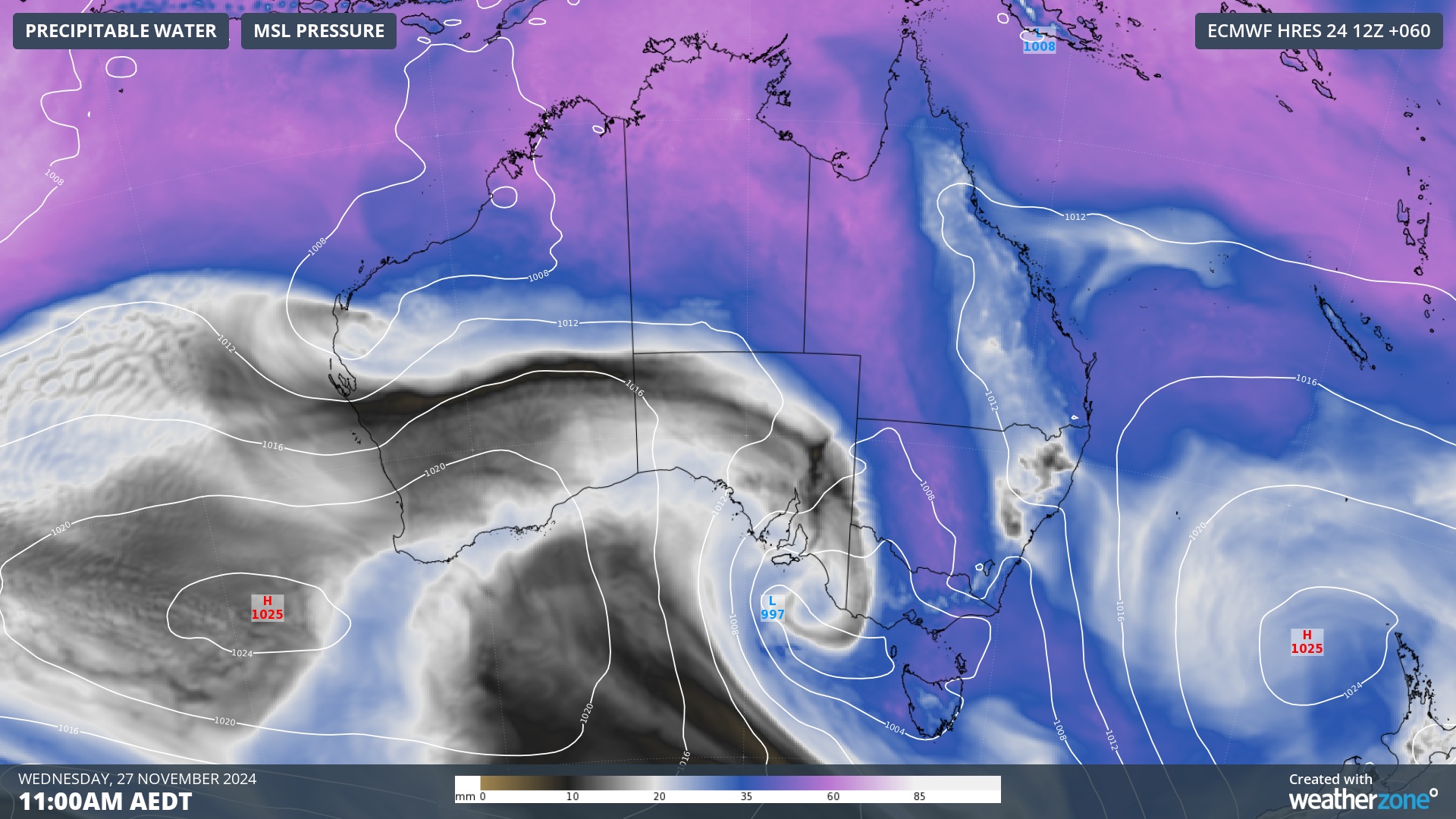
Image: Modelled precipitable water and mean sea level pressure at 11:00am AEDT on Wednesday, November 27, showing a large pool of moisture-laden air sitting over northern and southeastern Australia.
This week’s volatile weather set-up will result in widespread rain and thunderstorms that will see severe storms pummeling multiple states and territories in the final days of spring.
Where will the rain and storms occur?
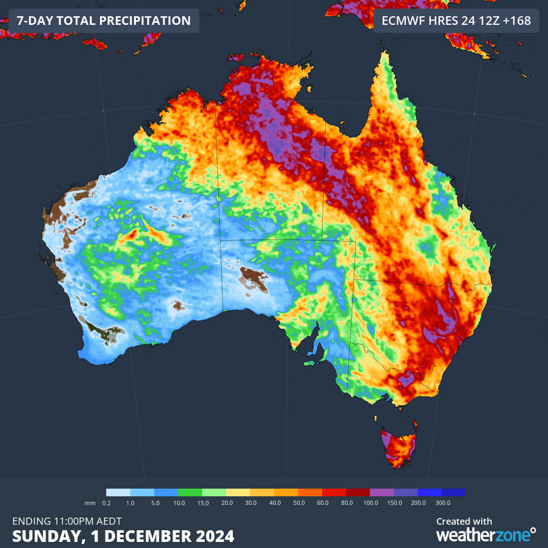
There aren’t many parts of Australia that will escape at least some wet weather in the last week of spring. The map below shows the predicted accumulated rain for this week from one computer model.

Image: Forecast accumulated rain during the week ending on Sunday, December 1, 2024.
Showers and thunderstorms will be a daily occurrence in northern Australia this week, impacting parts of WA, the NT and Qld.
Further south, rain and storms will pepper parts of southern and southeastern Australia early in the week before increasing and spreading further east through the middle and back end of the week.
While severe thunderstorms and areas of heavy rain are possible in every state and territory this week, the heaviest falls are likely to occur in a broad arc stretching across northern and eastern Australia, including parts of the NT, western Qld, NSW and possibly Vic, Tas and the ACT. Heavy rain and flash flooding will be a heightened risk with severe storms this week due to the abundance of atmospheric moisture that’s available.
Severe weather and severe thunderstorm warnings may be issued in multiple states and territories this week, so be sure to check the latest warnings in your area for the most accurate information.
- Other news
- Fri 27 Dec 2024 Why has Australia been so humid recently?
- Thu 26 Dec 2024 Record Boxing Day Test heat to scorch the MCG
- Thu 26 Dec 2024 The biggest Sydney to Hobart danger (apart from weather)
- Wed 25 Dec 2024 Highs and lows of Christmas weather in Australia
- Tue 24 Dec 2024 Cyclone Tracy 50 years on: a survivor's tale

