News
‹ back to weather news
News
-
Vast arc of lightning from Queensland to Victoria
Anthony Sharwood, 18 October 2024Melbourne, Canberra, and plenty of other places have been battered by severe thunderstorms on Friday, as an enormous storm outbreak rumbled and flashed its way across southeastern Australia.
The weather gods served up the perfect combination of ingredients for widespread explosive thunderstorm activity on Friday, with supercells – the most dangerous variety of thunderstorms – occurring in some areas.
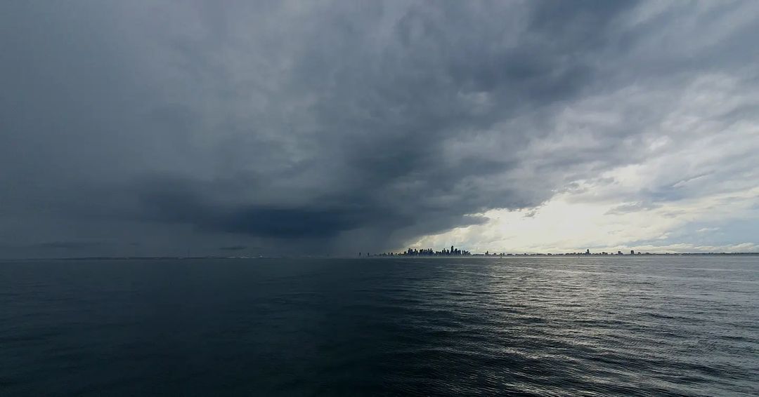
Image: Spectacular view across the bay to Melbourne as morning storms rolled in. Source: @Andrew_Ternes on Instagram.
The ingredients included:
- A low pressure system and cold front crossing southeastern Australia
- An upper-level trough
- Abundant atmospheric moisture
By 5pm, a vast arc of storms had formed in the unstable airmass just ahead of the cold front – stretching from the Qld/NSW border all the way down to the southern tip of Victoria.
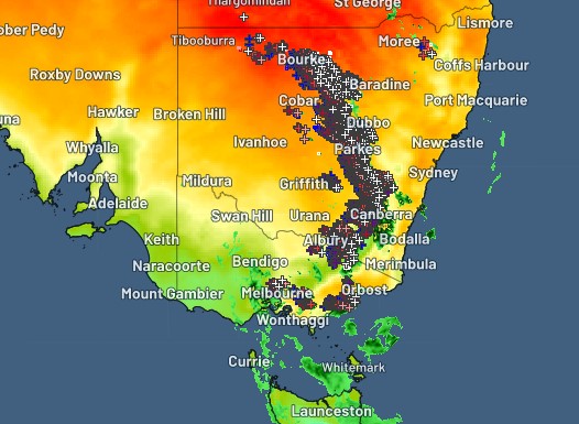
Image: Lightning stretched from The Qld/NSW border to the southern tip of Vic at 5pm on Friday, October 18.
Melbourne copped several storms on Friday. The most severe were just after 9am, when roads and even some businesses were inundated after more than 40mm of rain fell within a few hours in some suburbs. The southeast bayside suburb of Frankston received the heaviest rain.
There was heavy rain in the city's northeastern outskirts too, with one school crossing supervisor in Lilydale showing admirable dedication.
Hats off to this school crossing supervisor who’s knee deep in water, but still helping the kids cross the now ‘river’ in Lilydale. ???????? ????????
— Wazza from Melbourne (@Melbourne_says) October 18, 2024
What a legend! #melbourneweather pic.twitter.com/qcgMTEpWQRMeanwhile the storms rolled in to Canberra just before 5 pm, dumping only moderate totals in the city, but more than 25mm in the Cotter River catchment to the city's west, where it's always welcome. Other notable wind and/or rain totals for areas between Melbourne and southern Victoria on this wild Friday included:
- Thredbo in the NSW Snowy Mountains received more than 50mm (and counting) throughout the day, with wind gusts reaching 113 km/m at the top of the mountain.
- The Victorian Alps also copped the full brunt of the storms, with 58 mm at Mt Hotham between 9am and 5pm and a top gust of 104 km/h.
- Geelong eceived 67.6mm to 5pm, which meant it had already received more rain this Friday than in any entire month to date in 2024!
- Hail was also reported in numerous areas.
Friday’s strongest wind gusts were not quite as strong as the wild Thursday readings, when a gust of 137 km/h was recorded at Port Pirie on the eastern coast of South Australia’s Spencer Gulf, and transmission towers were toppled near Broken Hill. But it was still a seriously wet and stormy day.
Conditions will slowly start to clear over much of eastern Australia on Saturday and into the weekend, although showers will persist in Melbourne in a cool southwesterly airstream with maximums of 18°C and an apparent or “feels like” temp of closer to 10°C for most of the day.
- Other news
- Fri 18 Oct 2024 Rain relief for parched parts of Victoria
- Fri 18 Oct 2024 Destructive storm outbreak threatening NSW, Vic and ACT
- Thu 17 Oct 2024 South Australia’s highest October temperature in 29 years
- Thu 17 Oct 2024 Damaging winds to impact several states and territories
- Thu 17 Oct 2024 200 thousand lightning strikes with lots more to come