News
‹ back to weather news
News
-
Heavy rain to spread to New South Wales
Anthony Sharwood, 27 March 2025Heavy rain is spreading from Queensland into New South Wales, as a deep feed of tropical moisture tracks southwards, drawn into a broad low pressure trough.
Rainfall totals in many parts of Queensland have been huge this month – from the early March deluge in the southeast associated with Tropical Cyclone Alfred, to the extremely heavy falls in recent days and weeks in locations as far apart as Townsville and Birdsville.
Now New South Wales is in line for a soaking.
Indeed, the rain has already started. In the 24 hours to 9am Thursday, falls between 25 and 50mm occurred at numerous locations just south of the Qld border, and in the northeast corner of NSW. Moderate falls are continuing in that area through Thursday.
That's just a taste of what’s to come for the state as a whole. As the trough deepens and edges southwards on Friday and Saturday, a cold front (and upper trough) passing well south of mainland Australia will draw the trough over central and eastern NSW, generating widespread steady rainfall.
Sydney has seen relatively light showers on and off all week, but the period from Friday through to Sunday looks very wet, with Saturday likely to see the heaviest falls of 20 to 40mm, although totals may exceed that range.
Canberra has had only half its average monthly rainfall in the gauge to date in March, but that should change on Saturday, when heavy is rain expected (while Canberra obviously lies within the ACT, we mention it this NSW-centric story because the ACT itself sits entirely within the NSW Southern Tablelands forecast district).
As the map below shows, this event will be particular significant for parts of northern and central NSW.
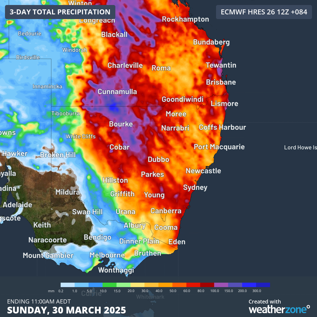
Image: Predicated rainfall totals through to 11am Sunday March 30, 2025 (AEDT), with purple and blue colours indicating the highest totals.
If we take Bourke as an example, the outback town of 2400 residents on the Darling River (you can see its location on the map above) has been exceptionally dry so far this year.
Just 1.8mm fell in January, followed by 1mm in February, while March was parched until 8.2mm fell in the 72 hours between 9am Monday and 9am Thursday this week.
The teasing falls of recent days are set to ramp up in the coming 48 hours, with big totals expected in Bourke between Thursday night and Saturday morning.
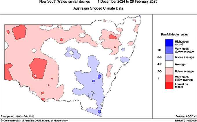
Image: It was a dry summer right across western NSW, as indicated by the red areas in the rainfall deciles map, highlighting areas where rainfall was below average or very much below average. Source: BoM.
Because of the broad-scale nature of the current weather pattern, areas of heavy rain can be expected all the way down to the NSW South coast in coming days, with only the southwest of the state likely to miss out on significant totals.
Indeed, the South Coast could see heavy rainfall into Sunday as a low forms just offshore over the Tasman Sea.
Please check the Weatherzone warnings page for the latest flood warnings and other alerts.
- Other news
- Sun 30 Mar 2025 Damaging winds rip through NSW coast
- Sat 29 Mar 2025 Cyclone Dianne delivers damaging gusts to WA Kimberley
- Fri 28 Mar 2025 12 hours of relentless rainfall in Mackay
- Fri 28 Mar 2025 Kimberley on flood alert as potential tropical cyclone looms
- Fri 28 Mar 2025 South Korea's largest wildfires on satellite