News
‹ back to weather news
News
-
Scorching heatwave intensifies over northern India
Felix Levesque, 23 April 2025A heatwave scorching northern India over at least the next seven days will place a tremendous strain on people and infrastructure.
The images below show the concerning heating pattern taking hold of India's north as the week progresses. Maximum temperatures are shown reaching the low to mid 40s on Wednesday, April 23 (top image), the mid 40s on Friday, April 25 (middle image), and soaring to the high 40s over parts of Pakistan and northeast India on Tuesday, April 29 (bottom image).
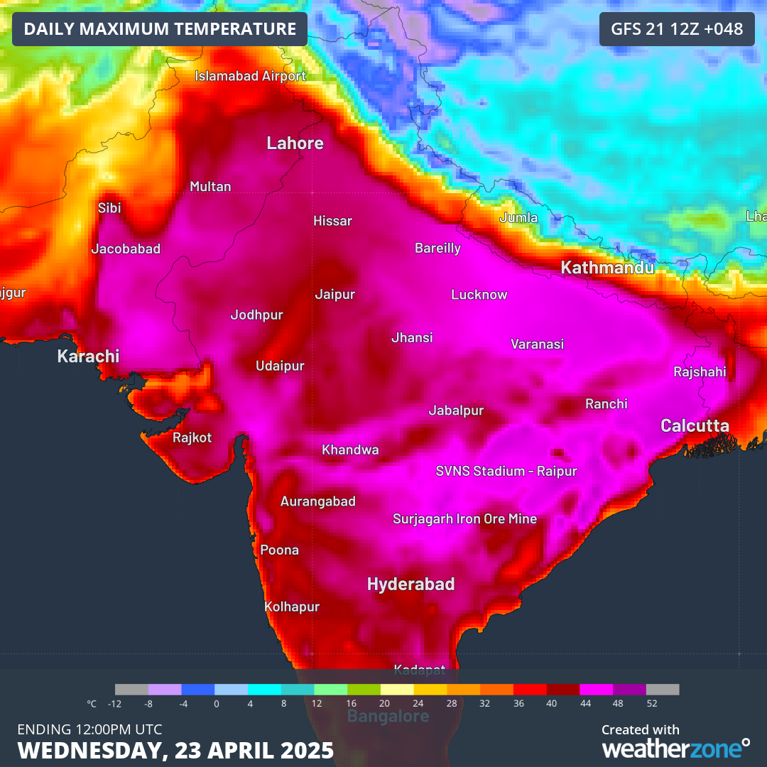
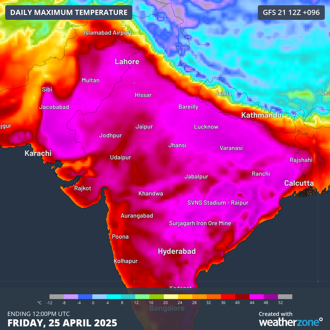
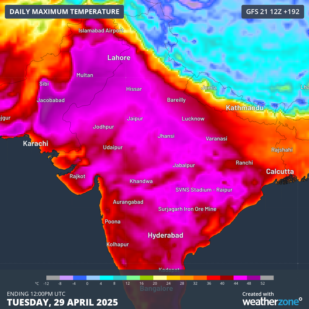
Images: Maximum temperatures on Wednesday, April 23 (top), Friday, April 25 (middle), and Tuesday, April 29 (bottom).
This persistent and oppressive bout of heat will be accentuated by overnight temperatures struggling to drop below the mid 20s throughout the coming week. Delhi is forecast to reach maximum temperatures of either 40 or 41°C, with nights only dropping to 25 or 26°C, until at least Sunday, April 27, about 3-4°C warmer than normal.
Where is this heat coming from?
Looking at the image below, much of the Indian subcontinent is expected to be mostly void of any rainfall until the end of this week. This is due to a high pressure ridge extending from the Arabian Sea, drawing hot and dry west to northwest winds from deserts to the northwest.
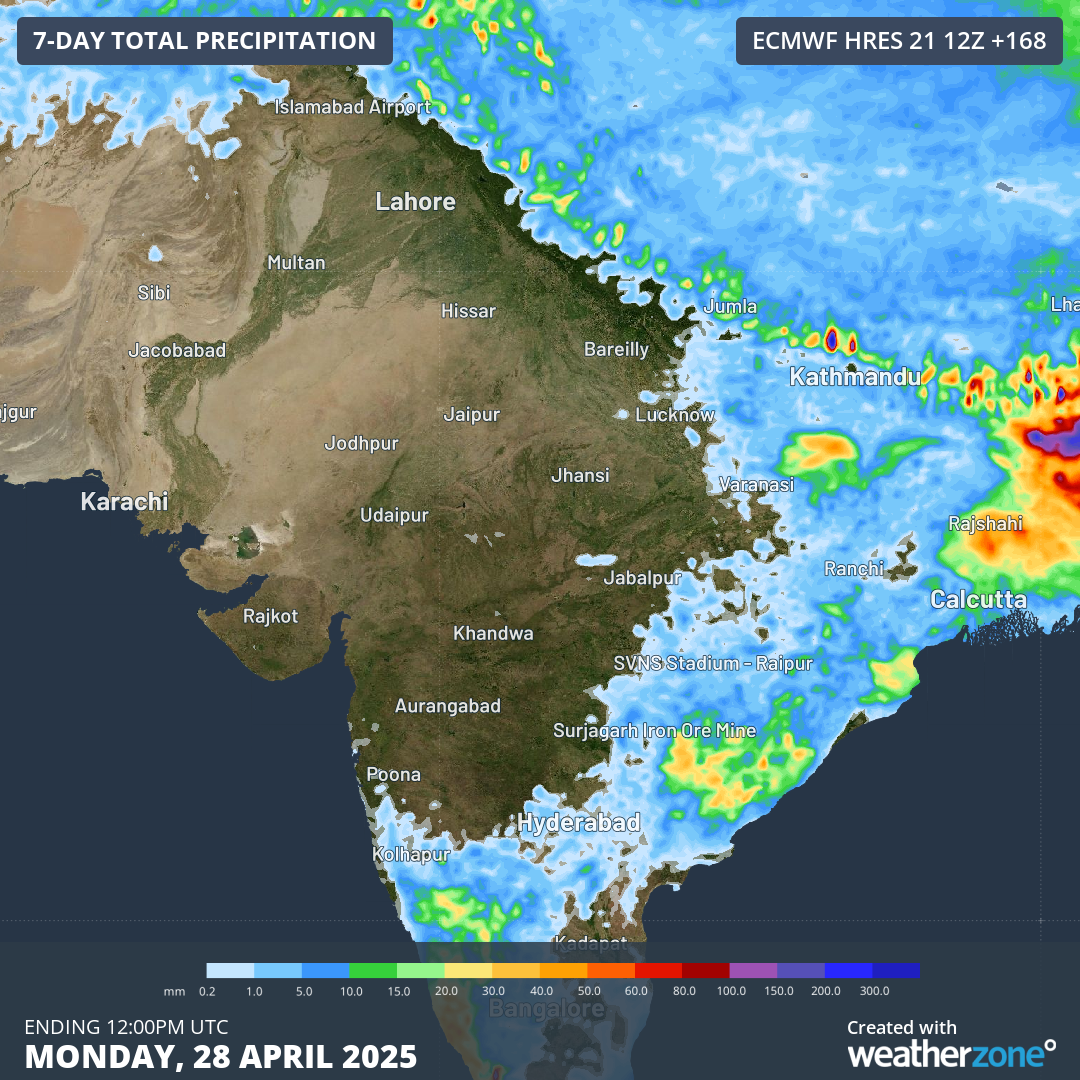
Image: Rainfall accumulations across India until Monday, April 28.
With little or no rainfall expected in the coming week, the hot and dry winds will maintain these intense heatwave conditions well into next week.
Is relief on the way?
Some thunderstorm activity and cooler temperatures are expected over Bangladesh and northeast India from this coming weekend and early next week. However, central and northern parts of the country may need to wait till later next week and possibly till the start of May before minor relief comes.
Early outlook for the Southwest Monsoon season rainfall
In mid April, the Indian Ministry of Earth Sciences put out a press release on the early outlook long range forecasts for the Southwest Monsoon seasonal rainfall. Some of the key takeaways from this early outlook included:
- An above average rainfall Southwest Monsoon season (105% of the long period average) for India as a whole.
- Normal Monsoon influences from Neutral conditions in both the El Niño Southern Oscillation and the Indian Ocean Dipole.
- Possible increase in Indian monsoon rainfall with below average snow cover over Eurasia.
Unfortunately, this above average rainfall outlook doesn't extend across the whole country. Parts of northwest and northeast India currently experiencing the searing heatwave are forecast to receive below average monsoon rainfall.
DTN APAC Explainer: The Indian Monsoon
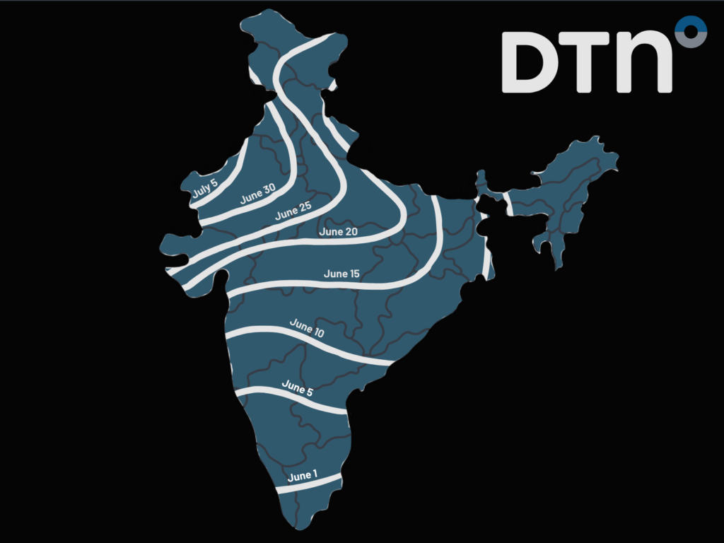
Image: The typical monsoon arrival date for Indian regions. Data: Indian Meteorological Department
The Southwest Indian monsoon typically sweeps over the Indian continent between late May and June, with rain lasting till about September. This brings about 80% of India's annual rainfall, however rainfall distributions across the country are immense.
Particularly across northern and central India, where the monsoon only arrives from about mid June onwards, the increasingly hot temperatures in May and June put tremendous stress on the people, agriculture and energy infrastructure. The arrival of the monsoonal winds bring much needed relief to most of the continent. However, there have been years where the needed rainfall has not progressed into the Delhi region and northwest India, which are referred to as monsoon failures. This brings tremendous stresses to people and industry depending on the needed relief.
- Other news
- Tue 22 Apr 2025 Soggy week ahead for the east coast
- Tue 22 Apr 2025 Nearly a million lightning strikes on wild NSW night
- Mon 21 Apr 2025 Easter bunny spotted in Australia's weather forecasts
- Sun 20 Apr 2025 ANZAC Day cold front all set
- Sun 20 Apr 2025 New data shows March 2025 was Earth's warmest on record