News
‹ back to weather news
News
-
47C heat and severe storms on the horizon for Australia
Ben Domensino, 10 January 2025A searing summer air mass could send temperatures soaring to the high 40s in parts of central Australia over the coming week, despite an ongoing barrage of rain and thunderstorms in other parts of the country.
Outback heat building
A large pool of hot air that has developed in the absence of seasonal monsoon cloud cover will linger over Australia during the coming week. This hot air could cause some of the highest temperatures so far this summer by early next week.
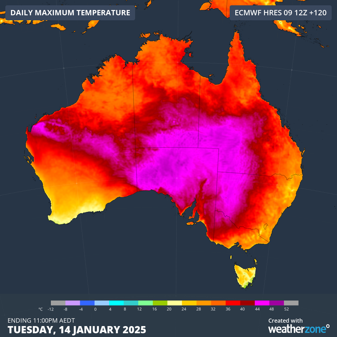
Air temperatures at the 850 hPa level in the atmosphere, which is roughly 1.5 km above sea level, are predicted to reach 30 to 33°C above some inland areas of Qld, the NT, SA and WA between now and the middle of next week. This type of heat aloft is capable of producing temperatures in the mid-to-high 40s near the ground.
Current forecasts suggest that temperatures could reach 46 to 47°C in pars of far western Qld during the first half of next week, while temperatures are also predicted to hit 45 to 46°C in the north of SA and the southern NT.

Image: Forecast maximum temperatures on Tuesday, January 14, 2025.
While the hottest air will remain over Australia’s interior during the next week, many coastal areas will also feel some warmth at times. Most of Australia’s state capital cities should have at least one day above 30°C in the coming week, with Adelaide possibly registering seven consecutive days over 30°C by next Tuesday.
This won’t be record-breaking heat for Australia, although it could be some of the hottest weather the country has seen this summer. Prior to this week, the highest temperature observed in Australia so far this season was 47.2°C at Birdsville.
Image: Daily forecasts for Birdsville, Qld on the Weatherzone app. Forecasts valid on Friday, January 10, 2025.
Rain and storms continue
The heat currently sitting over Australia is also helping to produce widespread rain and thunderstorm activity over the country’s eastern and northern states.
Warm and moisture-laden air is a key ingredient for thunderstorm development, so where the inland heat is meeting moisture-laden winds flowing off the warm seas surrounding Australia, conditions are ripe for storms.
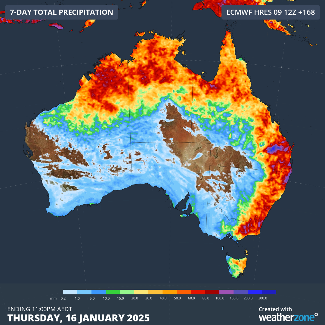
A flurry of overnight thunderstorms in southeast Qld produced a whopping 132 mm of rain in just 2 hours on North Stradbroke Island. Heavy rain and flooding will remain a heightened risk as more storms develop across a board area of eastern and northern Australia from today through to at least the middle of next week, possibly longer.
The ongoing rain and thunderstorm activity will cause some hefty rainfall accumulations over the next week or two. This rain enhanced further from late next week due to an increasing risk of the monsoon trough become established over northern Australia.

Image: Forecast accumulated rain during the week ending on Thursday, January 16, 2025.
There will be a heightened risk of flooding over northern and eastern Australia in the coming week, so be sure to check the latest warnings in your area.
- Other news
- Sun 12 Jan 2025 First Tropical Cyclone of 2025
- Sat 11 Jan 2025 Australian Open week 1 forecast
- Fri 10 Jan 2025 La Niña declared by US Climate Prediction Center – here's what it means for Australia
- Fri 10 Jan 2025 Northern Australia braces for increased cyclone risk, heavy rainfall and flooding
- Thu 09 Jan 2025 Exceptional Santa Ana winds behind devastating LA fires


