News
‹ back to weather news
News
-
Drought gripping SA, Vic as failed 'wet season' draws to a close
Ben Domensino, 30 October 2024Lacklustre rainfall over the past seven months has exacerbated drought conditions across large areas of SA and Vic, with Adelaide nearing the end of one of its driest ‘wet seasons’ on record.
The agricultural areas in SA and Vic typically receive most of their annual rainfall during the cooler months of the year between April and October. This rain typically comes from cold fronts and low pressure systems that come barrelling out of the southern Indian Ocean before sweeping across Australia from west to east.
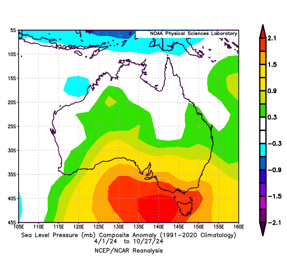
These cold fronts and low pressure systems have been lacking in 2024, with abnormally high pressure being a dominant feature across southern Australia and the surrounding region over the past seven months.

Image: Mean sea level pressure anomaly for the period from April 1 to October 27, 2024, showing abnormally high pressure near southern Australia. Source: NOAA
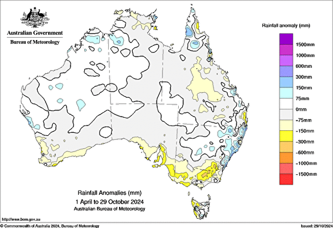
This relentless high pressure anomaly near southern Australia has resulted in below average cool-season rainfall across large areas of SA, Vic and southern NSW.
Many cropping regions in SA and Vic received less than 60% of their average rainfall between April and October in 2024. This translates to more than 150 mm of missing seasonal rainfall in parts of both states, including some areas in southern NSW.

Image: Rainfall anomalies for the period from April 1 to October 29, 2024. Source: Bureau of Meteorology.
The latest crop and pasture report issued by South Australia’s Department of Primary Industries and Regions predicts that the state’s grain production in 2024/25 will be 35% below average and the lowest in six years.
Farmers aren’t the only ones feeling the absence of rainfall in the past seven months either. Adelaide only received 248 mm of rain between April 1 and October 30, which is about 110 mm below its long-term April-to-October average and its 6th lowest total on record for this period.
Some of the abnormally dry areas in SA and Vic were also highlighted in Australia's latest seasonal bushfire outlook for their increased fire risk heading into summer.
The outlook noted that “fire authorities are advising communities of the potential for an early start to the fire season in parts of SA and Victoria, and extending to Tasmania if warm and dry conditions continue to dry out fuels towards summer.”
Looking ahead, there are no strong indications of above average rain or below average temperatures over southern Australia in November or December.
- Other news
- Sat 14 Dec 2024 Australia's heatwaves: the scorching past and present
- Fri 13 Dec 2024 Huge heatwave about to bake Australia
- Fri 13 Dec 2024 Canberra facing hottest day in almost five years
- Thu 12 Dec 2024 Victoria's first 45°C in four years on the horizon
- Thu 12 Dec 2024 'Everest of the Seas' races through Aussie waters

