News
‹ back to weather news
News
-
Hurricane risk may ramp up again for the US election
James Rout, 26 October 2024As punters focus on the US for the looming presidential election, meteorologists will be focusing on the tropical waters nearby due to the increasing potential for a burst of severe tropical weather late in the hurricane season.
The southeast US has recently had some respite from severe tropical weather after devastating hurricanes hit. This lull in the tropical Atlantic has been partly due to broadscale sinking air keeping a lid on convection.
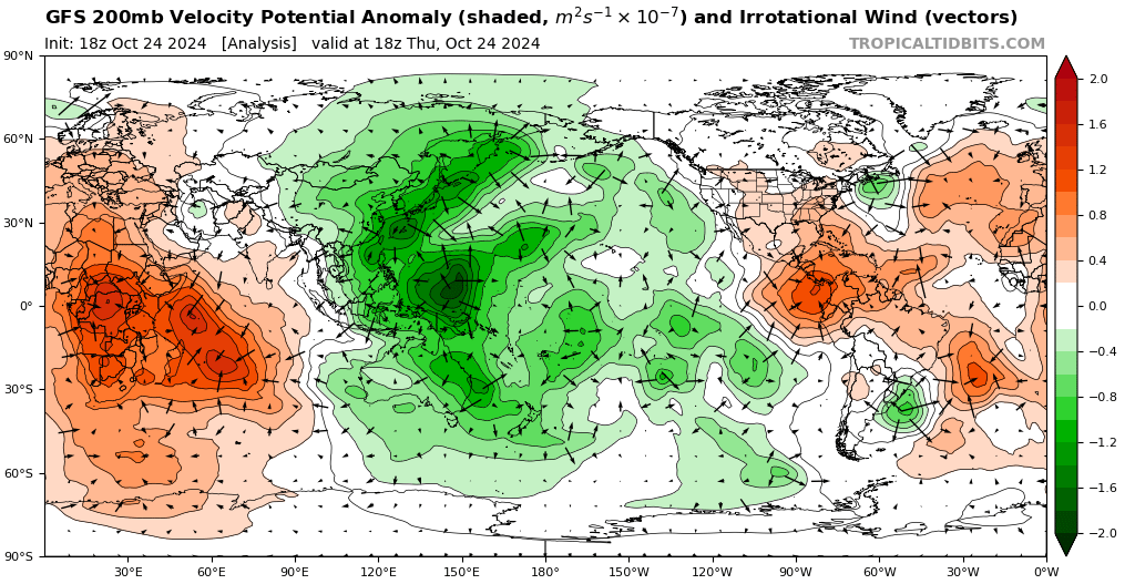
The orange areas on the following map indicate the general areas of sinking, as can be seen over the Atlantic. It doesn't necessarily prevent tropical cyclones altogether, but it generally makes it harder for them to develop.

Image: Regions of rising (green) and sinking (orange) indicated for 18Z October 24th. Source: tropicaltidbits.com. This map actually shows convergence and divergence at the 200hPa level from which we infer rising and sinking.
You need to pay special attention to green areas on the map because this indicates regions of broadscale rising air which is favourable for convection. This is like the lid being removed, and tropical cyclones can more easily develop.
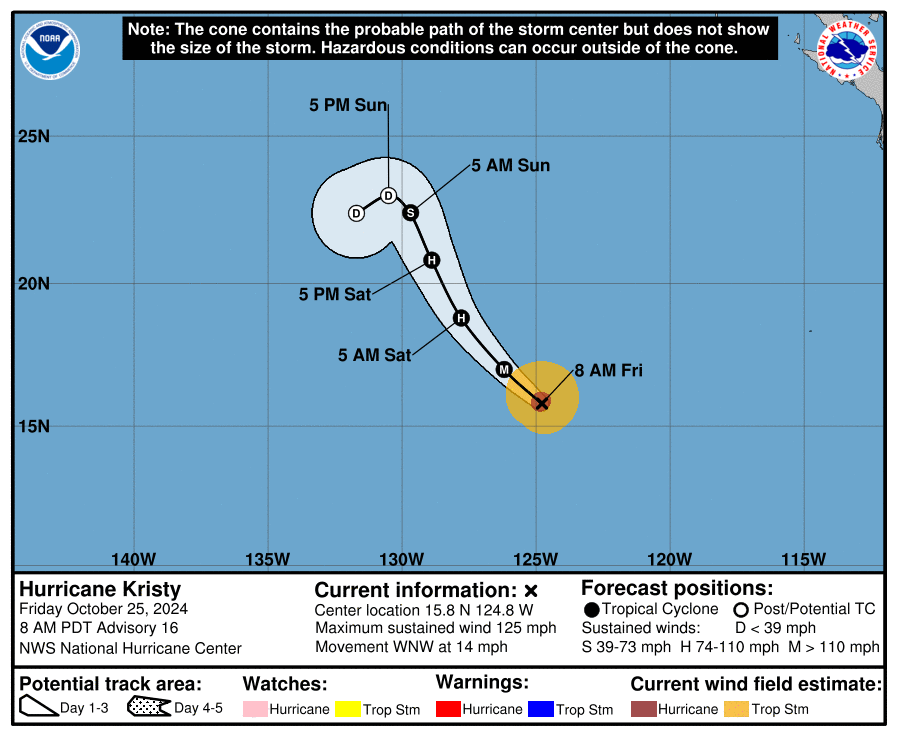
Currently there are more favourable conditions over the Pacific Ocean than the Atlantic Ocean, with Hurricane Kristy which briefly reached Category 5 status in the Eastern Pacific, and several tropical cyclones in the Western Pacific and Bay of Bengal.

Image: National Hurricane Center Advisory for Hurricane Kristy, Eastern Pacific, October 25th. The image at the top of the story is Hurricane Kristy at 21Z October 24th.
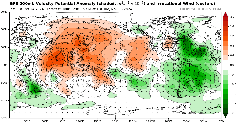
Looking to early November, you can see that the lid is forecast to be removed over the Atlantic.

Image: Rising (green) and sinking (orange) motion indicated for 18Z November 5th. Source: tropicaltidbits.com
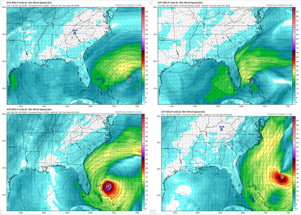
This doesn't necessarily mean that a hurricane will form over the North Atlantic region but it does increase the risk. And even though models will be indicating more active tropical weather around the time of the US election, it's too far in the future for models to accurately forecast a hurricane. Just take a look at the variations in four of the previous updates of the US global model forecast for 12Z November 5th.

Image: 10-m wind speed and MSLP forecast for 12Z November 5th from four previous runs of the GFS model. Source: tropicaltidbits.com.
Models will become more certain and accurate as we get closer to early November. Given the increased risk of severe tropical weather, it will be important to keep up to date with forecasts and warnings from the National Hurricane Center: National Hurricane Center.
- Other news
- Sat 14 Dec 2024 Australia's heatwaves: the scorching past and present
- Fri 13 Dec 2024 Huge heatwave about to bake Australia
- Fri 13 Dec 2024 Canberra facing hottest day in almost five years
- Thu 12 Dec 2024 Victoria's first 45°C in four years on the horizon
- Thu 12 Dec 2024 'Everest of the Seas' races through Aussie waters

