News
‹ back to weather news
News
-
Severe rainfall deficiency behind Grampians bushfire
Anthony Sharwood, 19 December 2024The bushfire in the Grampians National Park in western Victoria spread from 500 hectares to more than 5000 hectares from Wednesday into Thursday and continues to burn fiercely.
- The latest warning status, issued at 4:23pm on Thursday, was 'Watch and Act – Prepare to Leave' for the localities of Jimmy Creek, Mirranatwa, Bornes Hill, Grampians, Victoria Valley and Willaura.
- The Grampians National Park straddles two Victorian forecast districts – the Wimmera and the South West.
- The fire danger in both districts was rated as "Moderate" on Thursday, but with temperatures and winds set to increase in both districts on Friday, the rating in the South West for Friday is "High" while it will be "Extreme" in the Wimmera.
- Total fire bans are in place on Friday for the Wimmera and Mallee districts.
This year's rainfall data reveals why the region is currently at such elevated fire risk
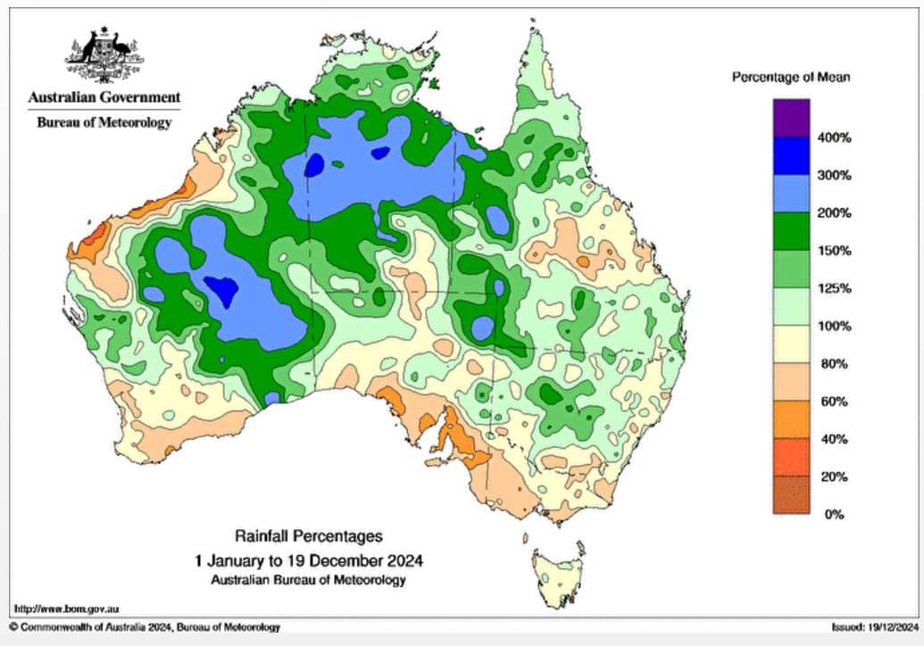
As the rainfall percentages map (below) shows, large parts of the country have had average or above-average rainfall in 2024 to date (the green and blue areas).
But the region extending from South Australia’s West Coast forecast district – all the way through southeastern SA and into western Victoria – has been one of the largest dry areas in the country (the brown and orange areas).

Image: Rainfall percentages across Australia in 2024 to date (up to Dec 18) with brown and orange areas representing 60% or less of the average rainfall. Source: BoM
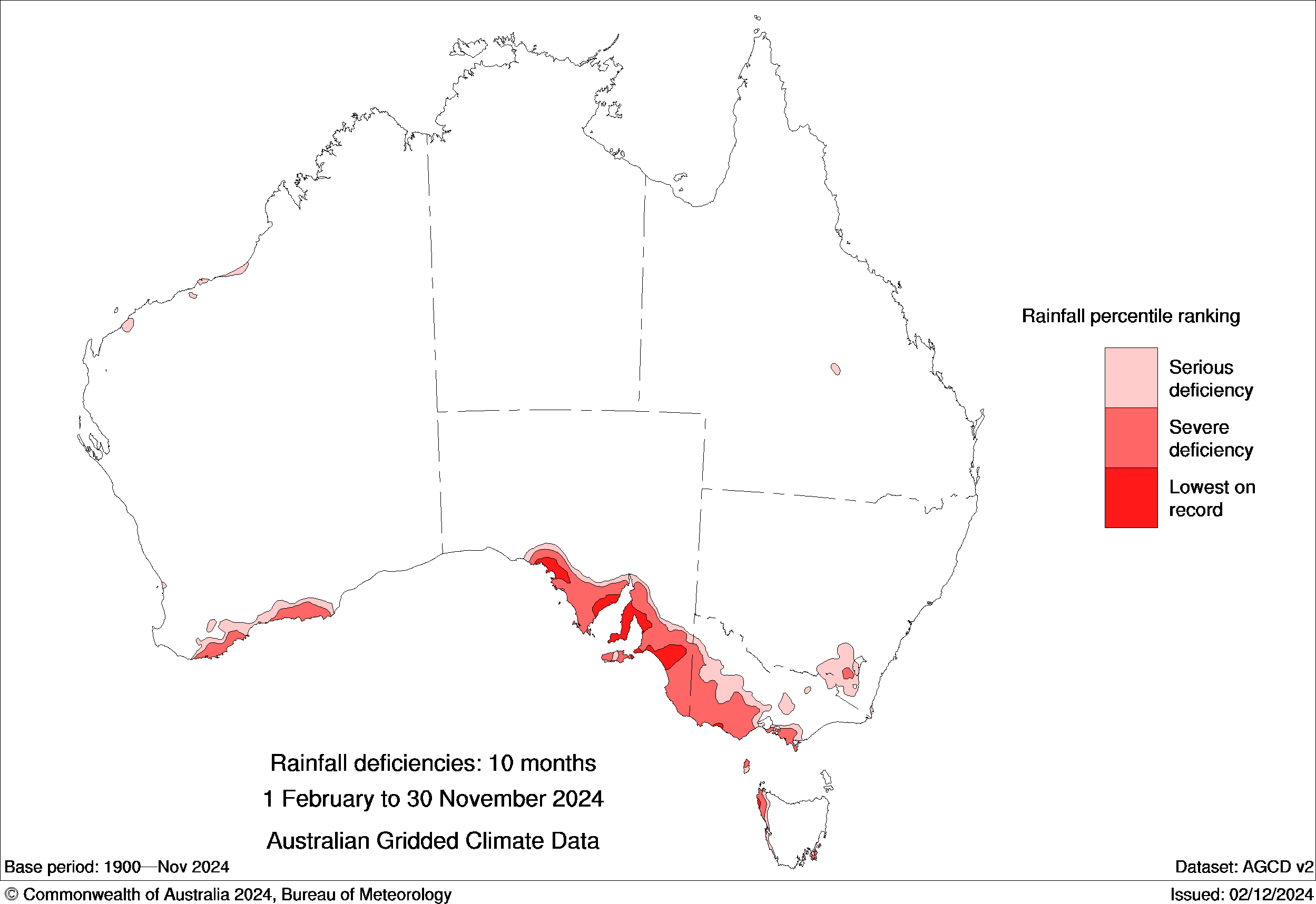
Another way of looking at the trend represented in the map above is to examine rainfall deficiencies. In the map below, the areas just mentioned in South Australia and Victoria stand out dramatically with severe deficiencies and in some cases, the lowest rainfall on record.

Image: Rainfall deficiencies across Australia from the start of February to the end of November 2024. Source: BoM.
Narrowing the focus down, here is the year-to-date rainfall data for four weather stations in the vicinity of The Grampians. The first two are in the South West forecast district, the latter two in the Wimmera.
The stats cover the period from January 1 up until 9am on December 19, 2024, compared to the annual average:
- Hamilton, Vic (south of the Grampians): Year to date 488mm. Annual average: 616.8mm.
- Ararat, Vic (east of The Grampians): Year to date 338.6mm. Annual average: 473.2mm.
- Horsham, Vic (north of The Grampians): Year to date 264mm. Annual average: 376.4mm.
- Edenhope, Vic (west of The Grampians): Year to date 276.2mm. Annual average: 485.5mm.
So whether you view the 2024 rainfall stats on a broad scale chart, or through individual weather station data, it's clear that much of western Victoria has had a very dry year.
Temperatures across Victoria have also been well above average in recent months, with the spring of 2024 the 6th-warmest on record statewide
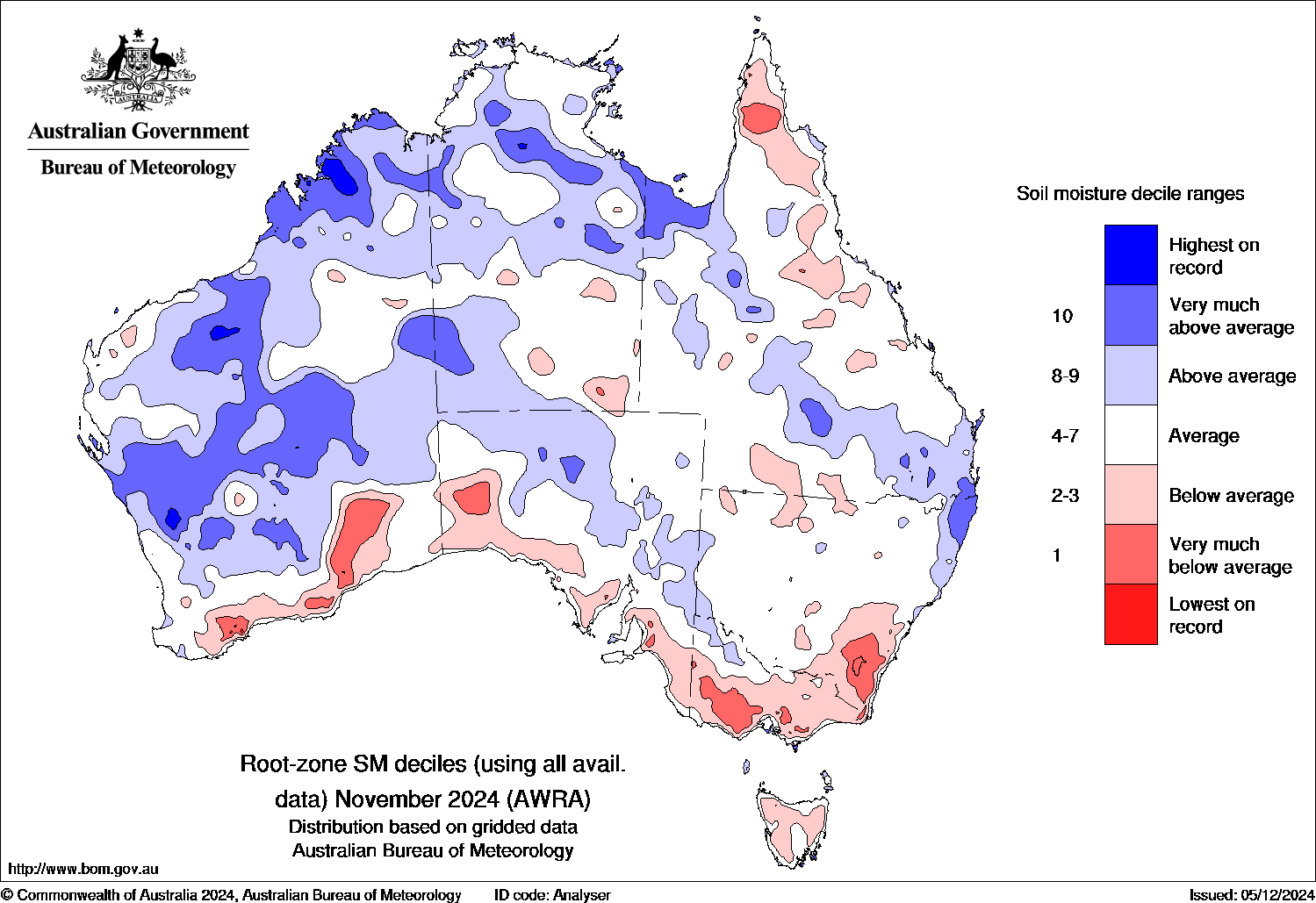
The most recent soil moisture map (for November) is another clear reflection of that pattern of below-average rainfall and above-average temps – with the large red blob of very-much-below-average soil moisture in western Victoria once again standing out.

Image: Map of root-zone soil moisture as a percentage of the long-term average for Australia in November, 2024. Source: BoM.
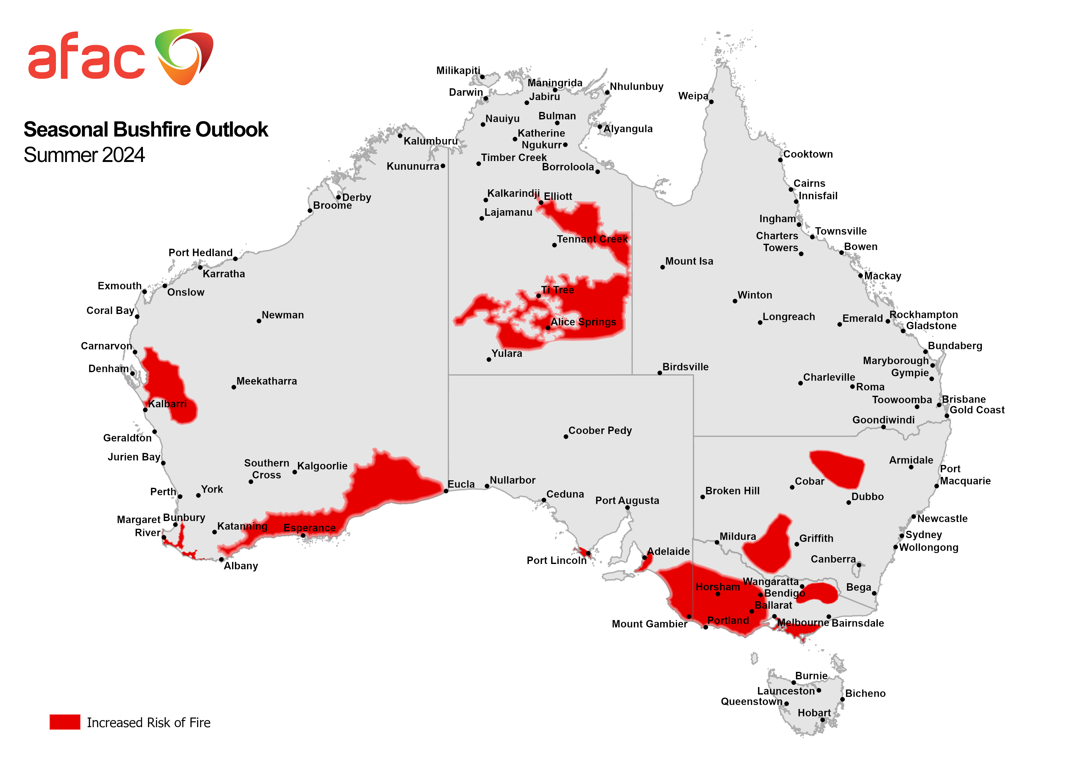
Any way you look at it, western Victoria has had a dry year. The current elevated fire danger in the region is a product of that rainfall deficiency, and indeed it was predicted in AFAC’s seasonal outlook – with western Victoria once again being one of the stand-out regions.

Image: The seasonal bushfire outlook for summer 2024/25. Source: AFAC.
- Other news
- Sun 22 Dec 2024 Queensland city beats December rainfall record before Christmas
- Sat 21 Dec 2024 Victoria bushfire forcing evacuations, smoke spilling into NSW
- Fri 20 Dec 2024 Relentless rainfall soaking northeast Queensland, more to come
- Fri 20 Dec 2024 Extreme heatwave hits WA, could set Perth's warmest December night on record
- Thu 19 Dec 2024 Hot Christmas Day on the horizon for Australia

