News
‹ back to weather news
News
-
Supercell storm wreaks havoc in Brisbane
Maryam Al-Ansari, 2 November 2024It was a perilous but electrifying time to be out and about in southeast Queensland (Qld) yesterday as a dangerous thunderstorm traversed the region, dumping giant hailstones in its path.
Compared to the sunny morning over the state capital, this storm seemed to come out of nowhere. But like all major thunderstorms, they must come from somewhere.
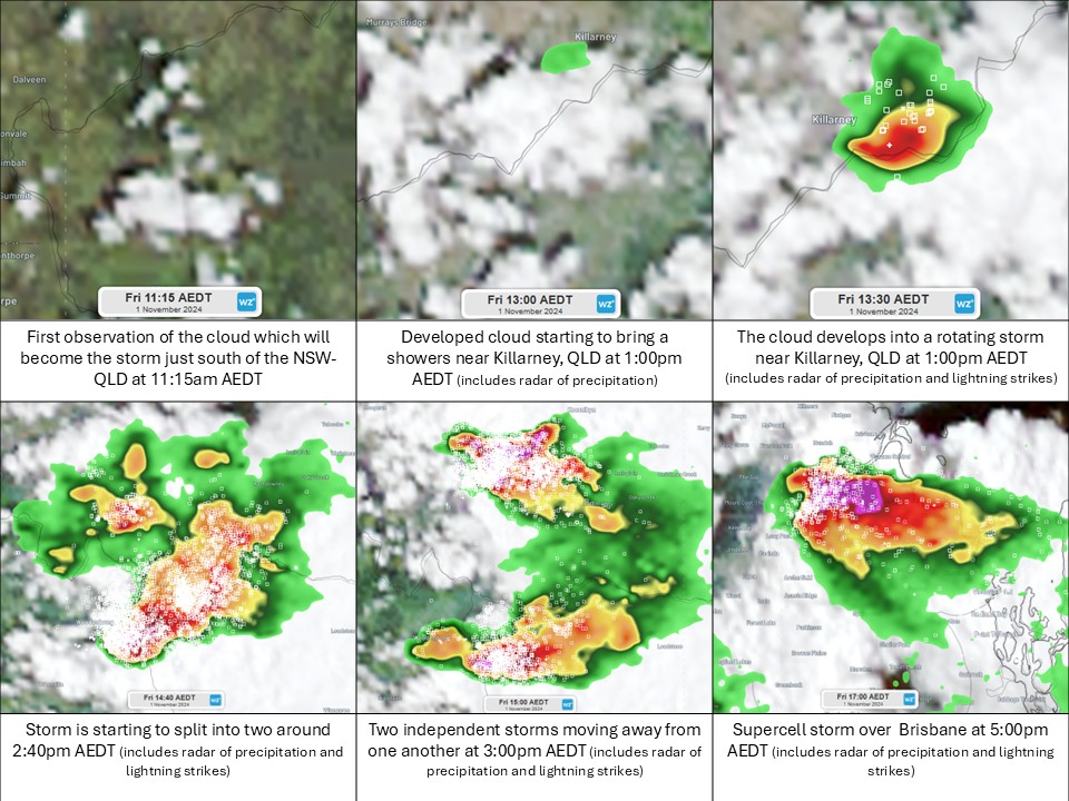
 Image: Evolution of yesterday’s storm over Brisbane
 At 1:00pm AEDT on the first day of November a cloud which had formed on the NSW side of the state border started to rain a light shower over the town of Killarney, Qld. Little did it know that it would evolve into a weather spectacle observed by thousands of people.
By 1:30pm AEDT, the eastward moving cloud developed into a storm with all the hallmarks of continuing to increase in intensity: the atmosphere was relatively humid at the surface to feed the storm with moisture; it was hot enough to keep the storm active; and the upper atmosphere looked prime to help any storm which developed to continue.
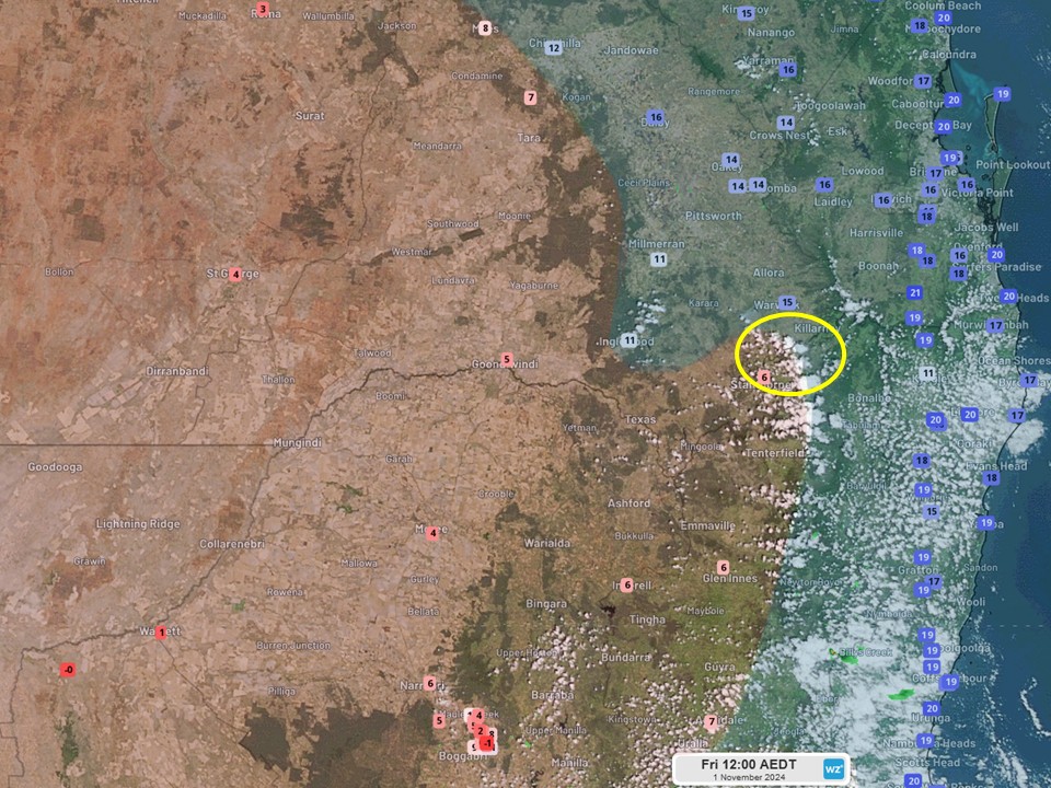
 Image: Satellite image at 12:00pm AEDT illustrating the location of the storm‘s initiation (yellow circle), relative to the dry and hot surface air of inland NSW and Qld, and the humid and mild surface air along the coast.
 At 1:46pm AEDT, the Bureau of Meteorology issued a severe thunderstorm warning for northeast NSW, followed by another warning for Qld at 2:00pm AEST (which means the warnings were issued more than an hour apart). Why the two warnings at different times? The winds around the storm had ripped it in two, moving one south into NSW and the other north into Qld, resulting in a severe thunderstorm warning for Qld. These types of storms are called splitting supercells, and in the southern hemisphere, the split cell which moves to the left of the “split zone” (in this case it would be the one moving north) tends to become stronger than its sibling to the right.
And that is exactly what was seen yesterday. The storm in Qld made a b-line for Brisbane, reaching the state capital in a matter of two hours and growing into a formidable supercell during that time (as seen by @Cal_Spencer’s X post).
Storm brewing in #Brisbane right now pic.twitter.com/sh3llrfvDK
— Cal Spencer-Rosenberg (@Cal_Spencer) November 1, 2024It brought around 34,000 lightning strikes during its lifetime, heavy rainfall and giant hail. Brisbane recorded 9mm of rain in 10 minutes between 3:50pm and 4:00pm AEST, and locals reported hail of all shapes and sizes reaching the size of a tennis ball. But that’s not all. The strong wind gusts from the storm created a rotating vortex over the Brisbane River, which looked like a tornado to onlookers:
Twister on the Brisbane River!!! ????️
— Tony Auden (@TonyAuden) November 1, 2024
From what I can tell this isn’t a fully fledged tornado, but more likely a “gustnado” that is a more transient feature on the leading edge of the storm.
Still looked like it had some strong winds in it though!
Credit: Hayden Oakley pic.twitter.com/SD6V8GoU5TThe storm eventually headed offshore into Moreton Bay at 4:30pm AEST, dissipating by 5:20pm AEST on the north shores of Moreton Island.
- Other news
- Sat 14 Dec 2024 Australia's heatwaves: the scorching past and present
- Fri 13 Dec 2024 Huge heatwave about to bake Australia
- Fri 13 Dec 2024 Canberra facing hottest day in almost five years
- Thu 12 Dec 2024 Victoria's first 45°C in four years on the horizon
- Thu 12 Dec 2024 'Everest of the Seas' races through Aussie waters

